Cold front to bring rain and snow to Northeast

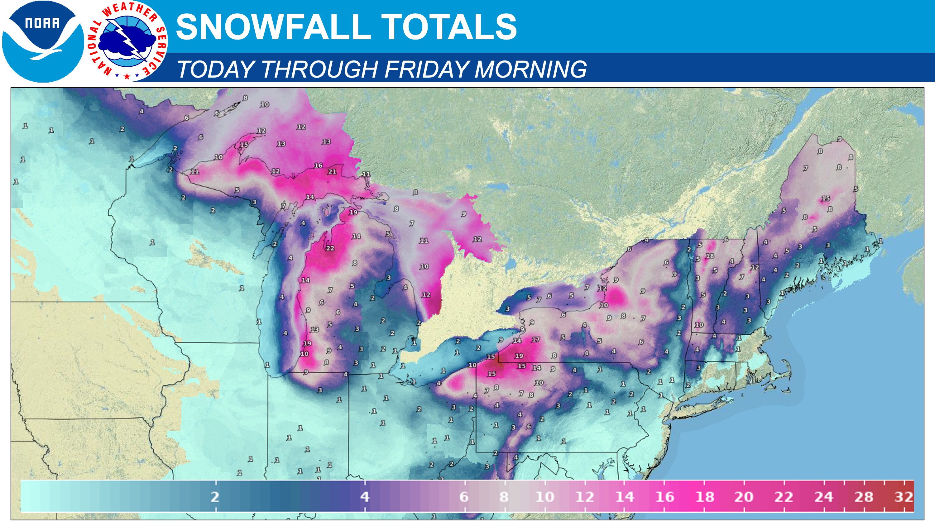
National Weather Service map of snowfall totals through Friday (Dec. 6) morning. NWS/Graphic
COLLEGE PARK, Md., Dec. 4 (ZFJ) — Bundle up, folks. A cold front is en route to the Northeast and is expected to bring rain and snow, strong winds, and freezing temperatures on Wednesday and Thursday.
“Beginning tomorrow, the passage of the Arctic cold front will lead to an outbreak of snow squalls containing intense bursts of snow and gusty winds upwards of 50 mph in the Upper Midwest and Great Lakes, which spread southeastward into the Central Appalachians and Northeast by Thursday,” according to the short range forecast issued by the National Weather Service’s Weather Prediction Center on Tuesday, Dec. 3, at 3:02 p.m.
“Over the lake-effect snow belts, 1-2 feet of snowfall can be expected, with heavy snow also possible across New England as the Clipper deepens to the north.”
NWS Philadelphia/Mount Holly remarked that the storm could cause some tree damage and power outages.
⚠️❄️🌬️ A strong cold front will impact the region Wed night through Thurs. Rain/snow showers Wed night and Thurs morning could result in some light snowfall. Strong winds developing on Thurs. The winds could result in some tree damage & power outages. #PAwx #NJwx #DEwx #MDwx pic.twitter.com/8bx2YEteM0
— NWS Mount Holly (@NWS_MountHolly) December 3, 2024
Winds will begin to build starting Wednesday night. Before they diminish early Friday, these highest gusts are possible. pic.twitter.com/USGCFHXuO8
— NWS Mount Holly (@NWS_MountHolly) December 4, 2024
Below normal temperatures will persist with dry weather expected through around sundown Wed. A strong cold front is forecast to push through late Wed into Thu morning bringing mountain snow (may include snow squalls) and very gusty west winds in the wake. #MDwx #VAwx #DCwx #WXwx pic.twitter.com/wBQhcGRmz6
— NWS Baltimore-Washington (@NWS_BaltWash) December 3, 2024
References
- Weather Prediction Center, National Weather Service - Short Range Forecast Discussion 2003Z Dec 03, 2024 - https://www.zfjnews.com/2024/domestic-affairs/WPCShortRangePublicDiscussion2003ZDec032024.pdf
- National Weather Service Philadelphia/Mount Holly - @NWS_MountHolly (X) - https://x.com/NWS_MountHolly/status/1863901558674739312 A strong cold front will impact the region Wed night through Thurs.
- National Weather Service Philadelphia/Mount Holly - @NWS_MountHolly (X) - https://x.com/NWS_MountHolly/status/1864108435060740111 Winds will begin to build starting Wednesday night.
- National Weather Service Baltimore/Washington - @NWS_BaltWash (X) - https://x.com/NWS_BaltWash/status/1863888162243899473 Below normal temperatures will persist with dry weather expected through around sundown Wed.
